The Introduction to Navigation, Map Reading and Route Planning Workshop is a practical one-day course designed to build confidence in navigating the countryside using a map and compass. Delivered by ML or HML qualified instructors, this workshop removes the mystery from navigation and replaces it with clear, usable skills that participants can apply immediately on their own walks.
Running from 09:30 to approximately 16:30, the day is split between relaxed indoor learning and hands-on outdoor practice. The workshop is suitable for those aged 16 and over, with under-18s welcome when accompanied by an adult. Group sizes are kept manageable to ensure plenty of support and opportunity for questions throughout.
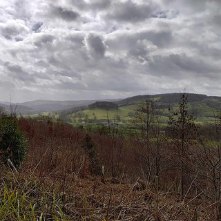
By the end of the day, participants will have the confidence to plan and follow their own lowland walking routes using the footpath network of the Peak District.
1. Choose the number of places you want to book.
2. Select course date.
3. Click ’Next’ and complete the attendee details for each place you have booked.
The Introduction to Navigation, Map Reading and Route Planning Workshop is a practical one-day course designed to build confidence in navigating the countryside using a map and compass. Delivered by ML or HML qualified instructors, this workshop removes the mystery from navigation and replaces it with clear, usable skills that participants can apply immediately on their own walks.
Running from 09:30 to approximately 16:30, the day is split between relaxed indoor learning and hands-on outdoor practice. The workshop is suitable for those aged 16 and over, with under-18s welcome when accompanied by an adult. Group sizes are kept manageable to ensure plenty of support and opportunity for questions throughout.
By the end of the day, participants will have the confidence to plan and follow their own lowland walking routes using the footpath network of the Peak District.

Introduction to Navigation, Map Reading and Route Planning Workshop - Derbyshire
Introduction to Navigation, Map Reading and Route Planning Workshop - Derbyshire

Introduction to Navigation, Map Reading and Route Planning Workshop - Derbyshire
Introduction to Navigation, Map Reading and Route Planning Workshop - Derbyshire

Introduction to Navigation, Map Reading and Route Planning Workshop - Derbyshire
Introduction to Navigation, Map Reading and Route Planning Workshop - Derbyshire
Learning the Essentials
The morning begins indoors at our World of Bushcraft Centre in Rowsley, where participants are welcomed with a brew and introduced to the core principles of navigation in a calm, comfortable setting.
During this session you will be guided through:
- Understanding maps, symbols, and key features
- Reading and using contours
- Map scales and distance calculation
- Using grid references
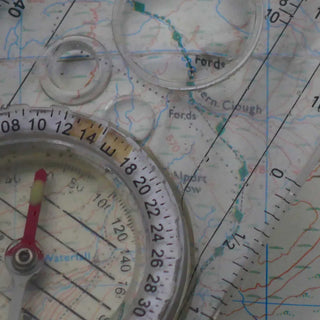
- Compass features and basic operation
- Simple route planning
- Equipment considerations
- Emergency procedures and common pitfalls
Maps and compasses are provided, allowing you to focus fully on learning rather than equipment. Instruction is clear, practical, and paced to suit beginners, with plenty of opportunity to revisit concepts before heading outdoors.
Putting It into Practice
Once the classroom knowledge is in place, the course moves outside to apply those skills in the real world. The afternoon session takes place on the footpaths around the Haddon Hall Estate, where participants work through practical navigation exercises supported by the instructor.
Skills covered outdoors include:
- Orientating the map in the landscape
- Identifying features on the ground
- Using the compass effectively in real conditions
- Taking and following bearings
- Using triangulation and features to fix position
- Converting distances into pacing and timing
This hands-on element is where confidence truly develops, bridging the gap between understanding navigation and using it independently.
A Supportive Learning Environment
The workshop is designed to be friendly, approachable, and confidence-building, whether you are completely new to navigation or looking to refresh existing skills.
Tea and coffee are available during the morning classroom session. For the afternoon participants should bring a packed lunch, water bottle, and suitable clothing and footwear for walking outdoors in variable weather. Maps and compasses are provided, although participants are welcome to bring their own if preferred.
Only paid participants will have resources allocated for hands-on participation. Under-18s must be accompanied by a responsible adult at all times.
In Summary
The Introduction to Navigation, Map Reading and Route Planning Workshop provides a clear and practical foundation in map and compass skills. Participants leave with the knowledge and confidence to plan routes, interpret the landscape, and navigate safely without relying on digital devices.
This workshop is ideal for walkers, bushcrafters, and outdoor enthusiasts who want to move beyond following others and begin navigating independently with confidence.