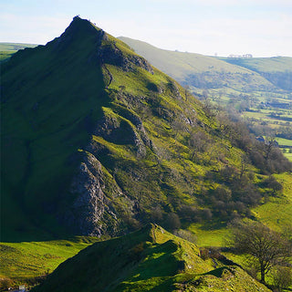
The Intermediate Map Reading and Navigation Course is a two-day, immersive hill-based programme designed to build real confidence in navigating the landscape using map and compass. Set in the outstanding terrain of the Peak District National Park, this course moves beyond classroom theory and places learning firmly where it belongs—out on the hills.
Led by Mountain Leader (ML) or Hill and Moorland Leader (HML) qualified instructors, the course develops the practical skills needed to plan and execute your own lowland and upland walks safely and independently. Every concept is taught through direct application in the landscape, ensuring skills are understood, retained, and genuinely usable.
Running midweek over two days, the course benefits from quieter hills, allowing for a more focused and enjoyable learning environment.
09:30 Thursday - 16:30 (ish) Friday
OPTION 1:
Buy this course as a gift voucher for someone else. Valid for 18 months.
BUY GIFT VOUCHER
OPTION 2:
Choose the number of places, pay a deposit now and the balance 8 weeks before the course starts or pay in full now.
Select from the dates below.
The Intermediate Map Reading and Navigation Course is a two-day, immersive hill-based programme designed to build real confidence in navigating the landscape using map and compass. Set in the outstanding terrain of the Peak District National Park, this course moves beyond classroom theory and places learning firmly where it belongs—out on the hills.
Led by Mountain Leader (ML) or Hill and Moorland Leader (HML) qualified instructors, the course develops the practical skills needed to plan and execute your own lowland and upland walks safely and independently. Every concept is taught through direct application in the landscape, ensuring skills are understood, retained, and genuinely usable.
Running midweek over two days, the course benefits from quieter hills, allowing for a more focused and enjoyable learning environment.

Intermediate Map Reading and Navigation Course
Intermediate Map Reading and Navigation Course

Intermediate Map Reading and Navigation Course
Intermediate Map Reading and Navigation Course

Intermediate Map Reading and Navigation Course
Intermediate Map Reading and Navigation Course
Course Structure and Setting
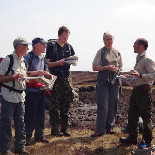
The course is run entirely outdoors and is fully hands-on. Participants are provided with maps of the area and work through a wide range of navigational challenges while moving through varied Peak District terrain.
The course begins in Edale, one of the most iconic walking locations in the UK. Each day typically runs from 09:30 to approximately 16:30, though exact finish times may vary depending on weather, terrain, group progress, and learning opportunities encountered on the hill.
Accommodation is not included, allowing participants flexibility. Cooper’s Campsite in Edale is highly recommended, offering excellent facilities and an on-site café. There are also numerous B&Bs and guest houses in the surrounding area. Participants should bring a packed lunch for each day, with evening meals available locally in village pubs.

Day One – Consolidating the Foundations
The course begins by revisiting and strengthening essential navigation skills, ensuring everyone starts with a solid foundation. These skills are refreshed and immediately applied in the landscape to reinforce understanding.
Topics include:
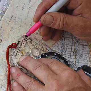
- Interpreting the map in relation to the surrounding terrain
- Understanding map scales and symbols
- Calculating distance and estimating journey times
- Giving accurate 4- and 6-figure grid references
- Setting the map to the ground
- Developing realistic timing and pacing strategies
This first phase ensures participants are comfortable translating what they see on the map into what lies around them on the hill.
Day Two – Taking Navigation Further
Building on the foundations, the course then progresses into more advanced navigational techniques. These skills are introduced gradually and practised repeatedly in real terrain, allowing confidence to grow naturally.
Advanced topics include:
- Orientating the map to identify key landscape features
- Calculating and following magnetic and grid bearings
- Walking accurately on a bearing
- Using attack points and collecting features
- Identifying hazards and managing risk
- Effective use of handrails and linear features
- Relocation strategies when position is uncertain
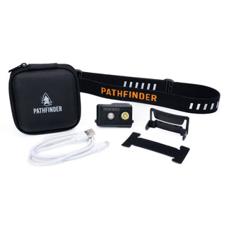
- Equipment choice and personal safety considerations
- Emergency procedures and decision-making
Particular emphasis is placed on contour interpretation, widely regarded as one of the most important navigation skills. Participants learn how to visualise the shape of the land from contours alone, enabling confident navigation even in poor visibility.
In Summary
The Intermediate Map Reading and Navigation Course provides a robust, practical step forward for anyone wishing to navigate with confidence in the British hills. By the end of the two days, participants will have developed the skills and judgment needed to plan routes, manage terrain, and move safely and efficiently through the landscape using map and compass alone.
This course is ideal for walkers, bushcrafters, outdoor enthusiasts, and those preparing for further qualifications or independent journeys. It offers not just technical skill, but the confidence to make sound decisions when it matters most.